
[Maps] Chorleywood is a village near London whose population has increased steadily since the
Chorleywood is a village near London whose population has increased steadily since the
middle of the nineteenth century. The map below shows the development of the village.
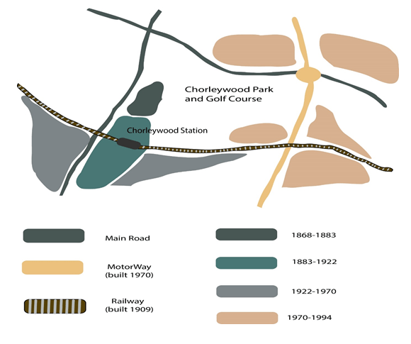
The map illustrates the growth of Chorleywood village from 1868 to 1994, with notable expansion corresponding to improvements in the transport infrastructure.
Overall, four distinct periods of development are evident on the map, each showcasing populated areas situated in close proximity to main roads, the railway, or the motorway.
Between 1868 and 1883, Chorleywood occupied a small area adjacent to one of the main roads. This original village area is now adjacent to Chorleywood Park and Golf Course. Subsequently, from 1883 to 1922, the village expanded along the main road to the south. During this time, in 1909, a railway line was constructed, traversing this area from west to east, with Chorleywood station located in this section of the village.
Further growth occurred from 1970 to 1994, particularly around motorway intersections with the railway and one of the main roads. This period saw the construction of a motorway to the east of the village, stimulating additional development around intersections with the railway and main roads.
(165 Words – Band 8.0)

Responses